This year, Simon took charge of the route planning, and providence took charge of the timing. Early last week, I borrowed Simon's marked-up 1:250000 Napier map, and started transposing the route into mapmyride, before eventually loading it onto my Garmin Edge 705. The basics: head north of Napier on Friday evening, and overnight somewhere on SH2. Ride into Tuai on SH38 on Saturday via some back-roads. Head to Minginui (south of SH38, about 30km short of Murupara) on Sunday via the Moerangi Track in Whirinaki Forest (czech out the latest 8th edition of Classic New Zealand Mountain Bike Rides), then return to the car via a southern route. Cool!
I found the last week or so prior to the trip stressful, largely due to bike anxiety. In the end, I threw a worn Stan's Raven on the rear of Flux Turner (replacing the humungous Nevegal), mounted a freeload rack on the rear triangle (all of about a 5 minute job), had a quick squizz at my Kiwi Brevet gear list and before I knew it, I was good to go!
Light is right: in a dry bag on the freeload rack I had a woolen singlet, long sleeved woolen top, shorts and undies, a Ground Effect Baked Alaska, plus jandals and my GPS charger. Also in the bag were toothbrush and toothpaste, some bog roll, and a few bike tools. I was testing out my new flash-as Octane 18X Camelbak (thanks to Extreme Gear for the support) - it was loaded with one square meals, rain gear, suncream and lip balm, chain lube and pump. Not a lot of stuff, but the essentials were present and accounted for!
I picked Simon up from work mid-afternoon on Friday, and soon we were unpacking the car into the Waikare Hotel, at Putorino, about 50km north of Napier.
We ordered a meal - I had a steak, which was accompanied by one of the biggest steak-knives I've ever seen! Simon's quote of the weekend came early: "good to have cutlery you can kill a man with"!

We watched some of the World Cup consolation final, before eventually turning in.
Saturday
The next morning dawned with the sound of light rain on the roof. We consequently made a leisurely start, enjoying the buffet continental breakfast on offer, and the Saturday edition of the Dom. We did the 5-minute quiz, managing only 6 correct.

We had 15km or so on SH2 to start, during which we shepherded a large flock of goats for a short while, before crossing the railway line onto Mohaka Coach Road. In the dry it would have been fantastic, but the gloop we were riding in resembled cold porridge, and we weren't having a lot of fun in it.

The road was quiet though, and apart from a single motorcyclist, we didn't see any other traffic before the crossing of the Mohaka River almost 20km later.
 | |
| Crossing the Mohaka River |
We stopped under a large tree before we passed the small settlement near the river-mouth. We had some food, and I took the opportunity to put my 3/4-length overtrou on - something I immediately regretted as for the first few minutes it felt like they were lined with sandpaper. Fortunately that horrid sensation ended, and I was soon back to gladness.
We were both wet and cold by the time we rolled into Wairoa - site of one of the ugliest churches I've seen in a while.

We hadn't intended on coming this way - we'd planned to backtrack on SH2 to Raupunga before hitting up a back road into SH38. But, the conditions had us seeking an easier route. The trip through Wairoa also gave us the opportunity to grab a bit of lunch at a cafe, some extra food from the supermarket, and Simon had a crack at buying some polypropylene to supplement his minimal gear. Despite cruising the entire town, the only option seemed to be a $2-store, and while Simon emerged with a new pair of "woolly" gloves, there was only cotton to be had and so it was a big fail on the warm clothes front.
Just out of town, we passed a funky teapot tree, which was worth doubling back for.

SH38 was very quiet, and apart from some very dodgy directions from the GPS,
 | |
| ORLY?! |
...we'd soon hit the gravel, and some quality scenery.


 | |
| Piripaua Power Station |
After checking out the info panel, we were getting stuck into the final climb of the day up to Lake Whakamarino and the settlement of Tuai. We chose the "back road", which was hugely ironic, given the fact that the parallel stretch of SH38 was gravel as well, and not much wider.
Piripaua Road afforded us a lovely approach into Tuai though, and was well worth the slightly steeper ascent.
 | |
| Tuai, on Lake Whakamarino |

Among our various forms of entertainment for the evening was trying to remember the 5-minute quiz questions (and answers) from the morning's paper. We only managed 8 out of 10.
The views out to the lake were stunning, and our host was a source of good conversation. We chatted for a bit, went for a short walk, and then hit the sack. Simon had a magazine which included info about the hydro scheme and the area more generally, and he occasionally reported bits of interest while I rested my eyes.
Sunday
When we woke the next morning, we were in the mist, but it was obvious the sun was doing its darnedest to cut through. We were treated to a cooked breakfast: deep-fried sausages and hash browns, an egg each, and toast, but our chef decided not to offer us any porridge - she didn't look that impressed with it. After posing out front, it was time to ride out.

We didn't get far before stopping to admire a bit of hardware from the power plant. Imagine the size of the socket-wrench for turning those puppies!

We took the main road out of town, SH38, gravelled, and before long were up above the mist. We were set for a stunner by the looks of it!
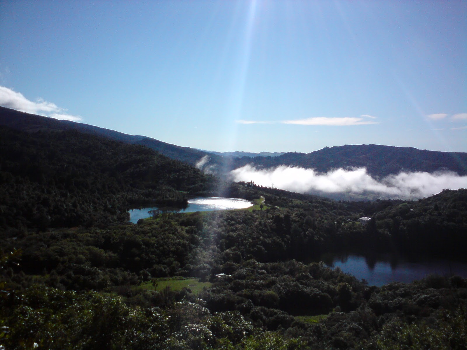 |
| Lakes Kaitawa (L), Wherowhero (R) and Whakamarino under the mist |
We faffed around a bit, stopping to take photos, apply sunscreen, shed coats etc etc, but were soon alongside Lake Waikaremoana. The lake itself was choppy with quite a wind blowing, but still spectacular.

For the next couple of hours we were riding alongside Lake Waikaremoana, and the scenery was off the hook.

About 250m down the road, my rear tyre started quickly losing air. Stan's jizz had been struggling to seal a hole just by the rim, and while I'd been able to top up the pressure every so often, this time, it was going down fast. I stopped and pulled the wheel out, before realising the hole had plugged itself again. I put some air in, and Simon recommended I let it settle a bit before riding off. I was riding a bit quicker than him, so he took the opportunity to get a head start.
I could have done with his moral support and experience in the minutes that followed. No sooner had he disappeared around the corner when I realised my rear brake was in a bad way. Not only were the pads touching, but the brake blocks were pretty much non-existant. One looked to have completely sheared off the metal backing plate, and the other was very thin indeed. In the end I managed to get my car-key in between them, and open them enough to get the wheel in. Then it was time to chase Simon...
The chase didn't go so well. As I set off my mind was whirring as to how the hell I'd manage to ride the next 200km with no rear brake. I must have knocked my GPS unit when I had the bike upside down cos when a strange noise prompted me to check my handlebar stem it wasn't there. I reeled the bike in (front brake only) and then turned around. About 150m back I saw the GPS sitting in the road. I guess somewhere in the data will be a rather sudden halt!
I had to reinflate my tyre a couple of times before I caught Simon. I quickly brought him up to speed on my shenanigans, and we were soon discussing cutting out the Moerangi Track. I felt pretty stink, but didn't see how I'd manage a day MTB ride nursing a compromised bike. Soon after, Simon reported rear brake problems of his own, and while I was calling time on my tubeless troubles, he diagnosed his rim was about to shit itself.
When we set off, both of us were on a strict diet of front-brake only.
The cruise along SH38 was fantastic. We very rarely saw any traffic, and if anything, had more altercations with wildlife. At one point we came across a herd of about 6 horses. They started hooning down the road in front of us, and I delighted in putting a massive attack in to pass them on their outside. Whoop whoop! It felt great to fire the legs in anger, albeit temporarily.
Soon we'd climbed away from the lake, and after a long descent we arrived at Ruatahuna - a pamphlet at the Whakamarino Lodge had assured us we'd be able to get pies and icecream here. Sadly, neither were available, but I did buy a tin of tuna which I ate with some grainwaves, a tin of creamed rice each (in the old colours, and $3.80!) which we ate with ice-cream sticks, and a big bottle of L&P. I couldn't be bothered grabbing a bottle outside, so used my creamed rice tin as a vessel... Yummo!

There was a greasies menu above the counter. Fish were first on the list at $3.70, followed by "Blood and guts" at $4.30. I could only surmise that was a hot-dog, since that wasn't on the list. I wish I'd asked the woman behind the counter...
There were a few tiny settlements beyond Ruatahuna, and these were always fascinating to see. Often a building or two, surrounded by fairly modern vehicles, and then junk strewn around the place.
The scenery continued to be stunning - often we were alongside a stream, and there was one super impressive cutting which I couldn't ride past without reaching for the camera.

We stopped for a spell at the top of a hill before beginning the descent. It was sealed - a rarity - and as we came onto a long straight we saw something in the road at the far end. We stopped, grabbed our cameras out, and rolled off down the road a bit more, both realising too late that we had cameras in the front-brake hand! We managed to stop though, before carefully considering how to safely negotiate the next 20m of state highway!

The huge cattle-beast in our rear-view mirrors, we were soon passing the turn-off to the Moerangi Track. Even if our bikes had been top notch, we were now well out of time, and wouldn't have made it through in daylight. The road section to the Minginui turn off was surprisingly hilly, but maybe we were both suffering a bit from a slightly stressful day, and about 200km in the legs so far.
It took us a bit of time to sort out where our accommodation was, but we got there in the end. We were sharing a farm-stay with Simon's bro Jonathan, Richie and Hannah from the Tāwhio and their friends, Mark and Sylvia. It was a while before Simon and I had access to the food Jonathan had driven in for us, but once we had it, it didn't take long for us to smash it down. The others made curry, and then we watched the ABs win the Rugby World Cup final against France. Our TV was small, and the reception was poor, so we didn't really get nervous until the commentator said it was "seven minutes to go". It still looked to be somewhere in the 50s on our screen!
Sunday
The next morning, Simon and I had creamed rice and bananas for breakfast, with a bit of fruit bread and a one square meal bar for good measure. We were travelling ever so slightly lighter today. We both had clean clothes back in my car, so we ditched a few non-essential garments. Consequently Simon was riding only with a small back-pack, and I wasn't hauling my jandals any more!
We rode the few kilometres into Minginui on the seal, before turning right towards a forest. We passed the turn to the Whirinaki MTB tracks and took the next left, onto a nice wide gravel road. The next 60km or so were off the hook, and are among the most amazing riding I've done.
The first task of the day was to gain some elevation, some 500 vertical metres. A lot of this was laid out in front of us, and after a while, we stopped to rearrange attire and lather up with suncream again.
 |
| Simon sets off, onwards and upwards... |
 |
| ...and the view back north towards Minginui |
Every now and then there would be signs of civilisation, but for the most part it was just us, the gravel road, and trees.


I was quite enjoying using my GPS unit as a copilot. I had the map screen zoomed in so I had only about 500m of track on the screen. When I saw a corner coming up, I'd check its radius on the screen before deciding whether or not to brake! Simon had no such need - he'd claimed his Cannondale back from Jonathan!
We were soon back in Hawke's Bay - we were about 50m up the road from where my GPS thought the boundary was, but the spot Simon was in looked like the watershed!
 |
| Bay of Plenty/Hawke's Bay boundary? |
For the most part the navigation was very intuitive. We'd started on Main Road, turned onto South Road, then Boundary Road. My GPS unit was proving very helpful though, and we made a hard left turn onto Main Road (again?). A few kilometres along, it suddenly started bleating. I called to Simon "it wanted us to turn right back there". Neither of us had noticed a track, so we turned back with trepidation.
A track was there, though it was very minor compared to the massive gravel roads we'd been riding. It looked like a forgotten 4WD road, reminiscent of parts of the Karapoti loop. We got Simon's 1:50000 map copies out, and confirmed the route. Then, we proceeded!!!! FUN!!!!!

For the next few kilometres, we trusted my GPS unit completely. We'd pop out into a clearing, and I'd look down to see which direction we'd exit in. It seemed to work well, though sometimes I felt like I had a bit too much going on. We'd probably have managed with just the paper maps, but it would have been very slow, and a lot more nervewracking!
Before too long we were dropping into a valley which would take us out to SH5. I almost came a cropper in a rut, but managed to keep my bike upright! Luckily it was dry, and I wasn't being hampered too much by the missing brake. There were times where I'd find myself enjoying letting the bike go a little too much though, resulting in a bit of a pucker while I reeled it in!
The stunning scenery continued, and we now had some mountains on the horizon ahead of us. It was amazing to feel the scale of the place, and to realise how much country we were traversing.

The complete absence of vehicles was soon explained by a massive fissure in the road, which took some negotiating, even with our light bicycles.

A while longer, and we were soon only a few hundred metres from SH5, probably about mid-way between Taupo and Napier. We had an opportunity to avoid half an hour on it though, and took what my map described as Pohokura Road, but which looked to be an overgrown 4WD track...
... which ended all of a sudden in a bunch of native bush. We made our way through, walking our bikes, and were soon staring into an open car grave.
We back-tracked a little, before picking up a small track on the left, and were soon smiling on the far side of the latest mid-road-chasm!
 |
| Minutes earlier we'd been staring into this from the other side! |

We had some stunning views over SH5 before a descent ending in the first gate of the day (about 70km into our journey).
 |
| Oops! |

The only hill before Tarawera had been used in the second (?) MTB nationals back in the day. Simon regaled me with a description of his older brother Paul puking after drinking a bidon filled with juice concentrate mixed with coke! The hill didn't seem so bad with a decent story being told in the background!
The prices at the cafe at Tarawera were daylight robbery, but we didn't care. Sandwiches and scones with jam and cream times two thanks, and I added a pie and coffee for good measure. We had our first real cellphone reception for a couple of days here too, and it was nice to touch base with a few folk at home.

When we set off, we had a couple of "monster" hills to contend with. Neither actually as big as they felt. The second one is up to the lowest saddle on the skyline, in the photo taken from the first!
 |
| Looking East |
It seemed to be doing a shocking job, and was recommending U-turns, and all sorts of crazy distances, but we knew better. By this stage we'd pulled the pin on the route it seemed to want us to take, and had scoped out another. We eventually discovered why it wouldn't allow us through, when we were confronted with a bunch of private road signs. Unfortunately, we were about 20km past the point of no return, so had no choice but to run the gauntlet. We passed near a house with a very vocal dog in the yard, but kept pedalling, our heads down, reciting "LALALALALALALALA" just so we wouldn't hear anyone hollering at us. It was stressful, and not at all pleasant.
After a short descent, we were again at a large mound of earth blocking the road. We'd seen this a couple of times before, and new instinctively that the bridge we were looking to cross was goneburger.
Without too much fuss we managed to get our bikes down into the riverbed - so many advantages to travelling light, and hike-a-bike sections being one of them. Simon called to me that there were people on the other side. Gulp. We didn't see anyone, though we did see a dog and a parked car. We walked briskly away from the car and were soon riding up a fairly steep 4WD road, chasing some billy goats.
Soon, we heard the sound of a vehicle, and Simon asked if I'd like to hide in the bushes. I replied "I'd rather be caught riding on this road than cowering in those bushes" - they didn't look like they'd offer much shelter. It was all academic, as the noise we heard was from a plane overhead. This prompted more great stories of Kennett Bros' missions from back in the day!
We had a nice surprise a few minutes later when a pink line appeared on my Garmin screen - signalling we were close to a route to Tutira! It was about 15 minutes away, and I was soon tucking into a massive icecream and a bit of jaffa slice! Simon arrived a few minutes later, and we got down to arm-wrestling to see who would blast the 15km back to Putorino.
I got my arse kicked...
It was nice to have an almost bare bike, and no bag on. It was good that I'd loaded my pockets with pump and tube though, because at "7 down, 8 to go" I felt my arse-end squirming around strangely, and had to stop to put extra air in the tube. I was keen to the the hell out of dodge on account of the magpie which was coming pretty close to my helmet. I cussed that bitch out though, and was soon full steam ahead to Putorino.
I figured if I made it as far as "11 down, 4 to go" before needing more air, I'd get away with just one extra pump. Luckily that was all it took, and I was soon retrieving the car, and then Simon, before starting the drive back to Wellington.
We managed to hold off our desire for dinner until Dannevirke, where we had a bit of Chinese smorgasbord followed by one hell of a lollie selection.
 | |
| Dessert! |
Men at Work's Business As Usual on the car stereo was a pretty fitting way to bring the trip to a close. The next day, Sarah asked Simon what on earth we talk about with so many hours together on these trips. The answer is all sorts of random shit, and sometimes nothing at all. It's one hell of a treat to have such a great mate to do these things with. The trip served us a few curve balls, and Simon was short a few training miles before it, but by god, that'll be one mission that's hard to top. I'm sure we'll try though...
Postscript
In no particular order: Somewhere over the rainbow (multichoice, a top movie song); 3 (sequels to Alien); Swallows and Amazons (an Arthur Ransome book set in the Lake District); Wales (multichoice about who'd beaten the ABs - I think Ireland and Scotland hadn't); Milkshake Maker (some appliance manufacturer in the 20s); the Dalai Lama (didn't get a visa to attend a party in South Africa - Desmond Tutu's 80th?), Poverty Bay (Cook's first landing in NZ). We remembered 9 of them on the ride, but only 8 at a time. I'm short 3 now!
Wow, another Great Journey you've taken us all on, although I'm going to have to admit to being a bit worried about what went on at the meating! Cheers for the top write-up, bro.
ReplyDeleteDamn, I can't possibly edit that out now! Good spotting!!!! So glad you enjoyed the read Oli!
ReplyDeleteFrida Kahlo (what female artist of the 1940s had a mono-brow).
ReplyDeleteNice write-up, mate. Thanks for carrying some of my gear, and your cheerful patience when I was blowing on the hills.
Ha - the "meating" made me giggle too :+) Awesome John - you have some fantastic adventures!
ReplyDeleteI liked you "czeching" it out, too! This is a great read: it provides heaps of "laugh out louds", several frissons of real-dangers-averted, some culinary astonishments and, as always, the joy of reading about my Sifter having fun.
ReplyDeleteAwesome write up!, enjoyed reading that, your epic rides are inspiring.
ReplyDeleteThank you all!
ReplyDeleteA couple of things I forgot: Simon and I got really confused about the distance to Te Whaiti from Ruatahuna. We thought we'd been there already. Turns out there's also a Te Waiiti on SH38.
I also got a bit confused by a sign on SH5 "Pure Adventures". I'd got so used to so much of the signage being in Maori, that it took me a while to click that "Pure" was in English...
Love your work John........
ReplyDeleteMy mum worked at the Ruatahuna shop back in the day.
I recall some cool missions on horse around Ruatahuna and Maungapohatu